



Your city didn’t develop a flood problem. It demolished the solution.
There is a question we rarely ask when the rain begins to fall heavily in Lagos: What stood here before the concrete arrived? Before the roads, shopping complexes, residential estates, and...

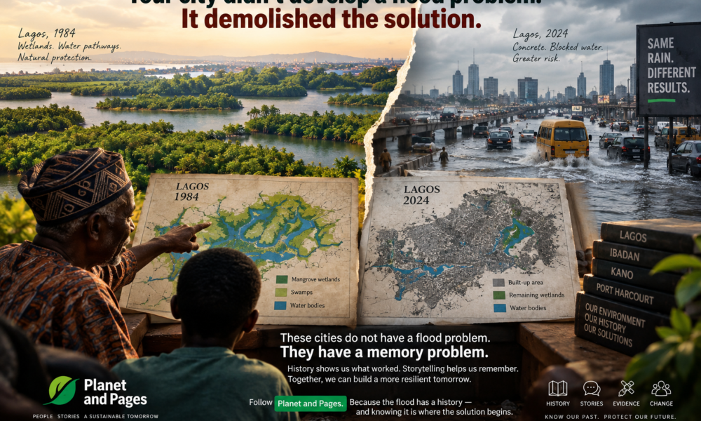
There is a question we rarely ask when the rain begins to fall heavily in Lagos: What stood here before the concrete arrived?
Table Of Content
- The Land We Forgot: Understanding Flooding Beyond the Drainage Question
- Lagos: When Wetlands Become Development Land
- The Numbers Tell a Story, but They Need Context
- Ibadan: The River, the City, and the Memory of Flooding
- A River Is Not Just a Drainage Channel
- Kano: Urban Growth and the Need for Evidence-Based Storytelling
- Port Harcourt: Expansion Across a Delta Landscape
- The Real Crisis Is Not Only Water. It Is Environmental Memory.
- From Disaster Reporting to Environmental Explanation
- Why Storytelling Matters in Climate Communication
- What Can We Do Differently?
- 1. Map What Existed Before
- 2. Record Community Environmental Histories
- 3. Communicate Research Beyond Academic Journals
- 4. Connect Environmental Knowledge to Planning
- 5. Make Solutions Visible
- The Role of Planet and Pages
- Conclusion: The Flood Has a History
Before the roads, shopping complexes, residential estates, and expanding neighbourhoods, what did the land do with the water?
Did it absorb the rainfall? Did it slow the movement of water? Did wetlands, streams, mangroves, and floodplains provide space for water to move without overwhelming communities?
These questions may sound like the concerns of environmental historians or urban planners. But they are also questions of survival, public communication, and collective memory.
Because when a Lagos neighbourhood floods, the conversation often begins with blocked drains, poor waste disposal, inadequate infrastructure, or the intensity of rainfall. These are important considerations. Yet they do not always take us far enough into the story.
Sometimes, the problem is not simply that water has become more destructive.
Sometimes, we have removed the places that once helped us live with it.
That is the argument this article explores: Nigerian cities need to understand their environmental history, communicate it in ways that communities can relate to, and include that knowledge in the search for more sustainable urban futures.
The Land We Forgot: Understanding Flooding Beyond the Drainage Question
Flooding in Nigeria is often discussed as though it were an isolated event. The rain comes, roads disappear beneath water, homes are affected, traffic slows to a frustrating crawl, and public officials are called upon to respond.
Then the water recedes, and the cycle of concern begins to fade.
But flooding is rarely only about the day water enters a street. It is also about what happened to the landscape long before that rainfall. It is about planning decisions, land conversion, drainage systems, settlement patterns, ecological degradation, and the ways in which cities have been transformed over time.
This distinction matters because it changes how we understand both responsibility and solutions.
A blocked drainage channel can contribute to flooding. So can intense rainfall, inadequate drainage capacity, poor maintenance, land subsidence in some locations, and development that disrupts natural water pathways. The relative contribution of these factors differs from one city and neighbourhood to another.
The important point is that urban flood risk is produced through the interaction of environmental processes and human decisions.
Research from Lagos illustrates the significance of this relationship.
Lagos: When Wetlands Become Development Land
Lagos is a coastal metropolis whose geographical character is inseparable from lagoons, swamps, mangroves, and other wetland ecosystems. These landscapes are not merely undeveloped spaces waiting for construction. Wetlands perform ecological functions, including floodwater storage, water regulation, sediment retention, and support for biodiversity.
A 2013 study by Obiefuna and colleagues examined spatial changes in the wetlands surrounding the Lagos and Lekki lagoon systems between 1984 and 2006. The findings are striking.
Mangrove wetlands declined from approximately 88.51 square kilometres to 19.95 square kilometres, representing a reduction of about 77.5 per cent. Swamps declined from 344.75 square kilometres to 165.37 square kilometres during the same period. The researchers linked these changes to urban development pressures.
CCSE
+1
These figures deserve more than a passing reference in an academic paper. They invite us to think about what the lost ecosystems were doing before they disappeared.
A wetland may not look like a piece of infrastructure in the conventional sense. It does not resemble a drainage culvert, pumping station, or concrete flood barrier. Yet it can provide important services without requiring the same kind of visible engineering structure.
When such spaces are converted, the consequences are not necessarily immediate or uniform. But the conversion can alter how rainfall is absorbed, stored, conveyed, and discharged. Where development reduces natural water retention or obstructs existing drainage pathways, heavy rainfall may produce more severe consequences, particularly when combined with inadequate infrastructure.
Lagos therefore presents an important lesson: the environmental costs of urban development cannot be assessed only by counting the buildings and roads that have been added. We must also examine the ecological functions that have been lost.
The Numbers Tell a Story, but They Need Context
There is a temptation in environmental communication to rely on dramatic statistics. A large percentage can attract attention, strengthen a headline, and create a sense of urgency.
But as scholars and communicators, we have a responsibility to handle evidence carefully.
The 2013 Lagos wetland study examined a defined geographical area and used satellite imagery, geographic information systems, and other supporting data to identify changes in land cover. Its findings should not automatically be presented as a complete account of all wetland loss across the entire Lagos metropolitan region or as proof that wetland conversion alone explains present-day flooding.
This distinction is not a weakness. It is what credible communication looks like.
An international audience deserves to know what a study actually measured, the period it covered, and what conclusions can reasonably be drawn from its findings.
The same principle applies when discussing other Nigerian cities. Historical land-cover statistics, flood records, and urban expansion estimates should be traced to their original studies before publication. A persuasive environmental argument becomes stronger, not weaker, when its evidence is transparent.
Ibadan: The River, the City, and the Memory of Flooding
If Lagos reveals the relationship between coastal wetlands and urban expansion, Ibadan offers another perspective on the consequences of changing urban landscapes.
The city has a long history of settlement, expansion, and interaction with its drainage systems. The Ogunpa River, which runs through Ibadan, has become closely associated with the city’s flood history. The major flood of 1963 is an important reference point in discussions of urban flooding and river management.
However, historical flooding should not be understood simply as a story of a river that suddenly became dangerous. The relationship between a river and its surrounding city changes as settlements expand, floodplains are occupied, vegetation is removed, and drainage pathways are altered.
A 2025 study published in Discover Environment examined land-use change and urban flood-risk management in Ibadan, focusing on Oluyole Local Government Area between 1990 and 2020. It reported a substantial decline in vegetation cover, from 74,892.42 hectares in 1990 to 37,700.19 hectares in 2020, within the study area. The researchers associated land-cover changes with reduced natural flood absorption zones and increased surface runoff.
Springer Nature Link
The geographical scope of this finding is important. The study concerns Oluyole LGA, and its figures should not be presented as though they represent every part of Ibadan.
Nevertheless, it points towards a wider question: What happens when urban growth progressively reduces the landscape’s capacity to absorb and manage rainfall?
A city needs roads, housing, schools, markets, industries, and public facilities. Urban development is not inherently harmful. The question is how development is planned, where it takes place, and whether the ecological systems that support urban life are considered in the process.
In Ibadan, as in other cities, flood management must therefore involve more than emergency response. It requires attention to land-use planning, river corridors, drainage infrastructure, vegetation, floodplain management, and the communities whose lives are shaped by these decisions.
A River Is Not Just a Drainage Channel
One of the challenges in public environmental communication is that we often reduce natural systems to their most immediate utility.
A river becomes a drainage channel. A wetland becomes vacant land. A floodplain becomes an attractive location for construction. Vegetation becomes an obstacle to expansion.
This way of seeing the environment can make it easier to overlook the multiple functions that natural systems perform.
A river has ecological, social, cultural, and hydrological significance. Communities may have historical knowledge about its seasonal behaviour, its dangerous points, and the changes they have observed over generations.
Such knowledge should not replace scientific measurement or engineering analysis. Neither should scientific expertise dismiss community experience as irrelevant. Each can contribute different forms of understanding.
This is where communication becomes central.
When an elder explains how a river behaved decades ago, that account may offer clues about historical conditions, land-use change, or community memory. When researchers compare those accounts with historical maps, rainfall records, satellite imagery, and hydrological data, they can develop a richer picture of how a landscape has changed.
The task is not to romanticise the past. It is to investigate it.
Kano: Urban Growth and the Need for Evidence-Based Storytelling
Kano presents a different urban and environmental context from the coastal landscape of Lagos and the riverine setting of Ibadan.
Its climate, settlement patterns, drainage networks, and history of urban expansion require their own analysis. We should not assume that the causes and consequences of flooding in Kano are identical to those in Lagos or Port Harcourt.
The script that inspired this article refers to extensive land-use change and flood impacts in Kano. Such claims need to be connected to identifiable studies, clearly defined geographical boundaries, and specific periods of analysis before being used as established evidence in an international publication.
This is especially important when communicating statistics involving very high percentages or large numbers of affected households. Readers should be able to distinguish between changes in land-cover categories, changes in the built environment, and the number of households exposed to or affected by flooding.
Yet the broader communication question remains relevant.
How do we explain the relationship between urban growth, traditional environmental knowledge, drainage systems, and flood risk in a city whose history and ecological conditions differ from those of southern Nigeria?
The answer must begin with local evidence.
Kano’s flood history should be investigated through historical records, geospatial analysis, local planning documents, community interviews, and relevant hydrological research. Environmental communication should make these findings accessible to residents without stripping away their complexity.
A city does not become more resilient merely because its residents hear the word resilience repeatedly. They need information that helps them understand their environment, recognise risks, participate in decisions, and evaluate proposed interventions.
Port Harcourt: Expansion Across a Delta Landscape
Port Harcourt provides another important case for understanding the relationship between urban expansion and ecological systems.
Situated within the Niger Delta region, the Greater Port Harcourt area includes a landscape shaped by wetlands, waterways, vegetation, and complex drainage conditions. Its urban development has transformed the relationship between built-up areas and surrounding land cover.
Research published in Urban Science examined land-use dynamics in the Greater Port Harcourt watershed from 1986 to 2003. The study reported that urban land increased from approximately 134.5 square kilometres to 550 square kilometres, representing a change of about 309 per cent.
ResearchGate
+1
The study’s findings offer a useful basis for considering how rapid urban expansion can alter the environmental conditions within a watershed.
However, a figure describing the growth of urban land should not be automatically interpreted as a direct measure of mangrove loss, nor should it be used by itself to establish the cause of a specific flood event. Those conclusions require more targeted evidence.
This is a recurring issue in climate and environmental communication: the desire to create a compelling narrative can encourage us to connect facts more confidently than the available research allows.
A responsible scholar must resist that temptation.
We can tell a powerful story about urban expansion, wetland degradation, and flood risk while maintaining the distinction between what a study demonstrates, what it suggests, and what still requires further investigation.
That approach also makes the story more credible to international readers, policymakers, researchers, and communities who may wish to act on the information.
The Real Crisis Is Not Only Water. It Is Environmental Memory.
When I describe the problem as a “memory problem”, I am not suggesting that Nigerian communities have forgotten everything about their environment. Across the country, people possess extensive knowledge of seasonal changes, waterways, farming conditions, settlement histories, and local ecological patterns.
The challenge is that this knowledge is not always documented, connected to formal planning processes, or communicated across generations and institutions.
Urbanisation can also produce a form of environmental amnesia. As new roads are constructed, houses emerge, and neighbourhoods expand, the historical landscape becomes less visible. A water channel may be covered. A wetland may be filled. A stream may be narrowed or redirected. The people who remember what existed before the transformation may eventually move away, grow older, or lose opportunities to share their experiences.
The physical landscape changes, and the story of that landscape becomes harder to access.
This is why historical environmental research matters.
A map from several decades ago can help reveal the former extent of a wetland or the location of a watercourse. Satellite imagery can show how land cover has changed. Oral histories can provide insight into how residents experienced those transformations. Government records may offer information about planning decisions, infrastructure projects, and flood events.
None of these sources is sufficient on its own.
But when they are carefully brought together, they can help communities understand how their environment has changed.
From Disaster Reporting to Environmental Explanation
Much of the public conversation about flooding is reactive.
A flood occurs, journalists report its effects, residents share images, officials announce interventions, and the public moves on to the next urgent issue.
This reporting is important. Communities need timely information about hazards, safety, response efforts, and public accountability.
Yet disaster reporting is only one component of environmental communication.
We also need explanatory storytelling that asks:
- How did this area develop?
- What natural water systems existed here previously?
- Which land-use changes have occurred?
- What do historical records tell us about earlier flood events?
- How do residents understand changes in their environment?
- What solutions are possible, and what evidence supports them?
These questions move the conversation beyond the immediate event.
They help audiences understand that environmental problems have histories, institutions, and human consequences.
For international audiences, this approach also challenges the tendency to present African cities only through images of disaster, vulnerability, or inadequate infrastructure. Nigerian cities are complex places shaped by innovation, economic activity, social relationships, political decisions, environmental change, and community resilience.
A serious account of flooding should recognise those complexities.
African communities should not be represented merely as victims waiting for external solutions. They should be understood as knowledge holders, participants in research, and actors in the development of local responses.
Why Storytelling Matters in Climate Communication
Climate change communication is often discussed in terms of awareness creation. We ask whether people know about climate change, understand its causes, or recognise its consequences.
These are important questions, but knowledge is not simply a matter of information transfer.
People interpret environmental issues through their lived experiences, social relationships, cultural backgrounds, economic circumstances, and levels of trust in institutions.
A resident of Lagos who has watched flooding disrupt transport, damage property, or affect household income may relate to climate risk differently from someone who encounters the subject through a global emissions chart.
Neither experience should be dismissed.
Scientific information helps us understand patterns, mechanisms, and projected risks. Community narratives help connect those issues to everyday realities. Effective communication brings these forms of understanding into conversation.
For example, rather than beginning a public discussion with a technical explanation of impervious surfaces, a communicator might ask:
When you were growing up, what happened to rainwater in this neighbourhood? Where did it go?
That question can open a conversation about environmental change without assuming that the audience lacks knowledge.
It can also encourage people to reflect on the relationship between memory, observation, and evidence.
The objective is not to replace science with storytelling. It is to make scientific knowledge more meaningful and accessible while recognising the knowledge that communities already possess.
This is particularly relevant to climate communication in the Global South, where environmental risks intersect with questions of inequality, governance, infrastructure, livelihoods, and public trust.
What Can We Do Differently?
If historical environmental knowledge can improve our understanding of urban flood risk, how can it become part of practical communication and planning?
1. Map What Existed Before
Historical mapping should be a more visible part of urban environmental education.
Researchers, universities, civil society organisations, journalists, and local authorities can collaborate to examine historical maps, satellite imagery, and land-cover records.
The aim is not simply to produce attractive visualisations. It is to communicate changes accurately and identify questions that require further investigation.
A before-and-after map can help audiences see how built-up areas, wetlands, vegetation, and waterways have changed over time. It should include clear dates, geographical boundaries, data sources, and explanations of its limitations.
Visual evidence can make environmental change easier to understand, particularly when it is accompanied by clear narrative interpretation.
2. Record Community Environmental Histories
Older residents often possess valuable knowledge about how neighbourhoods have changed.
They may remember former streams, seasonal water routes, wetlands, flood events, or changes in land use. Such accounts should be documented through ethical oral-history and qualitative research.
Researchers must recognise that memory can be selective and that individual accounts may differ. Oral histories should therefore be treated as valuable sources of experience and historical clues, not automatically as precise measurements.
When combined with documentary and scientific evidence, they can enrich the understanding of environmental change.
3. Communicate Research Beyond Academic Journals
Research that remains inaccessible to the communities it concerns has limited public communication value.
Universities and researchers should explore ways of translating relevant findings into accessible formats, including:
- Community forums and public discussions.
- Short explanatory videos.
- Newspaper features and digital articles.
- Interactive maps and visual stories.
- Radio programmes in locally relevant languages.
- Educational materials for schools and community organisations.
Communication should be adapted to the audience without compromising the integrity of the evidence.
A research finding should not become misleading simply because it has been simplified for public consumption.
4. Connect Environmental Knowledge to Planning
Communication is not a substitute for infrastructure, effective governance, or enforcement of planning regulations.
However, public understanding can support participation in planning processes and improve conversations about environmental risk.
Residents need opportunities to understand how land-use decisions are made, what flood-risk information means, and how proposed interventions may affect their communities.
Planners and policymakers, in turn, need mechanisms for listening to local knowledge and communicating decisions transparently.
The relationship between knowledge and policy is not automatic. But meaningful communication can help create the conditions for more informed public engagement.
5. Make Solutions Visible
A narrative about environmental destruction should not end with despair.
Communities need to know what forms of intervention are being considered, what their potential benefits and limitations are, and who is responsible for implementation.
Possible measures may include wetland conservation, restoration of appropriate water pathways, improved drainage maintenance, floodplain management, urban planning reforms, early-warning systems, and other locally suitable interventions.
The appropriate combination will depend on the characteristics of each location. No single intervention can resolve every urban flooding problem.
A credible communication strategy should therefore distinguish between established evidence, proposed measures, and outcomes that remain uncertain.
The Role of Planet and Pages
At Planet and Pages, we see environmental communication as more than the publication of information about climate change.
It is an opportunity to connect research with public experience, scientific knowledge with local narratives, and environmental history with the choices that shape the future.
Our interest in historical maps, oral histories, satellite imagery, and community storytelling reflects a broader conviction: people deserve access to environmental information that is understandable, relevant, and grounded in evidence.
The question is not whether every resident should become a hydrologist, urban planner, or climate scientist.
The question is whether environmental communication can help people ask better questions about the places where they live.
What has changed?
Why has it changed?
Who has been affected?
What knowledge is available?
What solutions can be evaluated?
And how can communities participate in building a more sustainable future?
These are not questions reserved for academic conferences. They belong in public conversations, schools, neighbourhood meetings, media platforms, and policy discussions.
As a Nigerian scholar working at the intersection of communication and environmental issues, I consider this connection particularly important. The way we communicate environmental problems influences how those problems are understood, discussed, and potentially addressed.
Good communication does not promise that every challenge has an easy solution. It creates room for evidence, dialogue, accountability, and informed action.
Conclusion: The Flood Has a History
A city is more than the buildings that stand in it.
It is also the rivers that run through it, the wetlands that once stored its water, the vegetation that covered its soil, the pathways through which rainfall moved, and the memories held by the people who have lived there.
When these histories disappear from public understanding, we lose part of our ability to interpret the present.
Flooding in Lagos, Ibadan, Kano, Port Harcourt, and other Nigerian cities cannot be explained through one universal narrative. Each urban area has its own environmental conditions, development history, governance challenges, and flood-risk patterns. The evidence must be investigated carefully, not forced into a convenient story.
Yet one principle is widely relevant: sustainable urban development requires attention to the ecological systems that make cities liveable.
The task before us is not to reject development. It is to ask whether development can take place without unnecessarily destroying the environmental functions on which communities depend.
It is also to communicate these questions in ways that people can understand and engage with.
Because when a community learns what stood on its land before the city expanded, it gains an opportunity to reconsider the relationship between history, development, and environmental risk.
And when knowledge becomes part of public dialogue, it can contribute to more informed choices.
The flood has a history.
Understanding that history is not the whole solution. But it is a meaningful place to begin.
Follow Planet and Pages — where people, stories, and evidence come together for a more sustainable tomorrow.


No Comment! Be the first one.